- A new tropical storm has organized near Honduras, Belize and Mexico.
- Flooding rain is possible in parts of Mexico and Central America the next several days.
- A second tropical wave is also being monitored for possible development as it tracks westward into the Caribbean Sea.
- The western Caribbean is a favored area for tropical development in October.
Tropical Storm Gamma is expected to be a flooding rain threat in parts of Mexico and Central America as the Caribbean Sea remains busy with tropical activity.
Here's the latest on the two active systems in the Caribbean.
Tropical Storm Gamma
The new tropical storm is spreading showers and thunderstorms from western Cuba to parts of Central America and continues to become better organized.
Gamma will track generally toward Mexico's Yucatan Peninsula, including Cancún and Cozumel, Belize or the far southern Gulf of Mexico into this weekend.
Tropical storm warnings have been issued for portions of Mexico's Yucatan Peninsula from Punta Herrero to Cabo Catoche. Tropical storm conditions are expected there by this weekend. Tropical storm watches have also been issued elsewhere on the Yucatan peninsula.
Watches, Warnings
(A watch is issued when tropical storm or hurricane conditions are possible within 48 hours. A warning is issued when those conditions are expected within 36 hours.)With a lack of shearing winds and deep, warm water, this system should gradually intensify if it remains over the waters of the northwestern Caribbean Sea or the southern Gulf of Mexico. Any additional land interaction will limit the amount of strengthening that can occur.
A Hurricane Hunter mission is scheduled to investigate on Saturday.
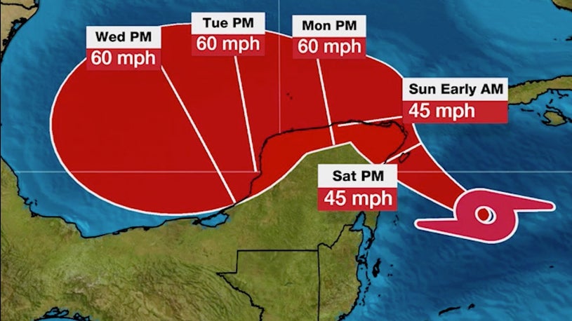
Latest Information
(The red-shaded area denotes the potential path of the center of the tropical cyclone. It's important to note that impacts (particularly heavy rain, high surf, coastal flooding, winds) with any tropical cyclone usually spread beyond its forecast path.)It is currently expected that this system will reach the southern Gulf of Mexico on Sunday or Monday.
From there, the track is expected to move west or southwestward in the Gulf of Mexico or Bay of Campeche.
The trend on Friday was for a more southern track through the Bay of Campeche.
The intensity forecast is complicated by the system's proximity to land, the aforementioned deep, warm water, the potential for it to ingest some drier air over the western Gulf of Mexico and potential wind shear it could face in the southern Gulf of Mexico.
Water Vapor Satellite Image
(This satellite image shows areas of dry air in progressively darker orange colors and more moist air in gray, purple and blue colors. The current location of the tropical system is shown by the symbol.)While not an immediate, apparent threat, it's too soon to rule out any eventual U.S. Gulf Coast impact.
For now, all interests in Mexico's Yucatan Peninsula, western Cuba and Belize should monitor the progress of this system.
Second Caribbean System
The other disturbance is now pushing into the eastern Caribbean Sea.
The second area being monitored is a tropical wave that is moving across the eastern Caribbean Sea.
Current Locations of Disturbances, Infrared Satellite
(The circle shows the approximate location of the eastern Atlantic tropical wave.)This disturbance will continue to push westward over the next several days and, for now, has a medium chance of development by early next week as it tracks toward the western Caribbean Sea.
It's too soon to determine if this system will develop, where it might track and how strong it may become.
Interests in the western Caribbean should monitor the progress of this system.
Flood Threat
This setup could lead to dangerous flash flooding in parts of eastern Mexico, Belize, Guatemala, El Salvador, Honduras and Nicaragua.
Rainfall totals of 4-8 inches are expected in Mexico's Yucatan peninsula and far western Cuba, with up to 12 inches of rain locally possible. Very heavy rainfall is also possible in southern Mexico, including rainfall totals locally up to 20 inches.
Also, moisture-laden winds on the eastern flank of the tropical storm intercepting a stalled frontal boundary could wring out heavy rain in parts of the Florida Peninsula, leading to flooding which may also combine with high astronomical tides.
Rainfall Forecast
(Locally heavier rainfall is possible.)Even though the climatological peak of the hurricane season – Sept. 10 – has passed, residents along the Gulf and East coasts need to remain prepared for a hurricane.
Roughly one-fifth of all U.S. hurricane landfalls have occurred in October and November.
(MORE: What the Busiest Hurricane Seasons Have Delivered in October)
The Weather Company’s primary journalistic mission is to report on breaking weather news, the environment and the importance of science to our lives. This story does not necessarily represent the position of our parent company, IBM.
"enter" - Google News
October 03, 2020 at 07:11AM
https://ift.tt/2EZDjdY
Tropical Storm Gamma in the Northwestern Caribbean; Expected to Enter Gulf of Mexico - The Weather Channel
"enter" - Google News
https://ift.tt/2TwxTMf
https://ift.tt/3d6LMHD
Bagikan Berita Ini


0 Response to "Tropical Storm Gamma in the Northwestern Caribbean; Expected to Enter Gulf of Mexico - The Weather Channel"
Post a Comment